Click on a photo to see the album.

Sunday, July 31, 2011


Sunday, July 24, 2011
Day 24 - Refuge Tagnarede to Banyuls-sur-Mer
24th July 2011
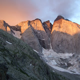
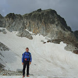
The final day! On the map this looked like a straightforward saunter down to Banyuls. But this morning I was greeted by a galeforce northerly wind as I stepped out from the shelter of Refuge de la Tagnarede. Being persistently battered by a freezing cold wind for the next few hours made the traverse to Pic Sailfort a bit of a battle.
However, as soon as I began the descent from Pic Sailfort the wind began to ease. It was strange bumping into a couple of French guys who'd just started that morning heading in the opposite direction along the GR10. They had a good month of adventures ahead of them, whereas in a few hours my journey would be over.
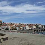
There is no great sense of satisfaction or pleasure at getting to the end of one of these big hikes, it's more a question of keeping focussed to the end to get the job done. When you arrive at Banyuls, nobody is interested that you've just hiked 800km from the Atlantic, so I just quietly sat by the beach for a few minutes before seeking out the train station to get away from the scorching heat and pink bodies frazzling themselves on the beach.
The biggest relief came when I arrived at the train station, bought my ticket to Girona and then slumped in the air-conditioned waiting room, knowing that I could finally relax.
View HRP - Day 24 in a larger map
 |
| HRP - Day 24 |
The final day! On the map this looked like a straightforward saunter down to Banyuls. But this morning I was greeted by a galeforce northerly wind as I stepped out from the shelter of Refuge de la Tagnarede. Being persistently battered by a freezing cold wind for the next few hours made the traverse to Pic Sailfort a bit of a battle.
However, as soon as I began the descent from Pic Sailfort the wind began to ease. It was strange bumping into a couple of French guys who'd just started that morning heading in the opposite direction along the GR10. They had a good month of adventures ahead of them, whereas in a few hours my journey would be over.
There is no great sense of satisfaction or pleasure at getting to the end of one of these big hikes, it's more a question of keeping focussed to the end to get the job done. When you arrive at Banyuls, nobody is interested that you've just hiked 800km from the Atlantic, so I just quietly sat by the beach for a few minutes before seeking out the train station to get away from the scorching heat and pink bodies frazzling themselves on the beach.
The biggest relief came when I arrived at the train station, bought my ticket to Girona and then slumped in the air-conditioned waiting room, knowing that I could finally relax.
View HRP - Day 24 in a larger map
Saturday, July 23, 2011
Day 23 - Moulin de la Palette to Refuge Tagnarede
23rd July 2011
I got up quietly to have a 6am breakfast with the Gite owner Laurent. There were a couple of other guys helping at the gite as part of the WWOOF project for developing organic farming. After a long leisurely breakfast, the other hikers were emerging. I managed to get going by 7am, but almost immediately reached a fork on the trail and took the wrong option. I should have taken the lefthand upper trail, but the lower track looked like the main route.
I followed this through a gate and up some switchbacks which I should have realised were heading the wrong way, when suddenly 2 dogs starting barking insanely and a guy came out of the farm I was trying to pass unnoticed. He looked at my map, and told me I was heading up the wrong hill. I tried to find my compass to confirm this, but he said a compass would be of now use. He told the only way to navigate these hills was to watch the sun, but then looked up and said "only there is no sun today". I thanked him as I turned around to head back down again, and he said "today I saved your life".
Soon I was back at the fork, and took the upper trail and found the small wooden sign pointing to "Roc de France" with blue marks. This was quite a fiddly trail that lead up to Col Cerda 1058m, which would have made a good camping spot. The trail then improved as it re-joined the GR10, but became quite fiddly again as I tried to follow the high ground over Roc de Frausa which had several rocky summits.
I took a short break once I reached the Refuge des Salines (briefly back in Spain), then followed forest tracks back to the border at Col de Lly for the short descent to Las Illas.
The section from Las Illas to Col du Perthus was mainly along forestry pistas, and with afternoon fatigue kicking in, it was quite hard to stay awake. It was after 4pm when I reached the grim border town of Le Perthus. This really is a place you want to get in and out of as quickly as possible. I grabbed a bagful of shopping from the first supermarket, and starting walking up the hill straightaway. The GR10 has recently be re-routed at this point to take you through rough scrubland, rather than hiking up the road. It would probably have been quicker to have walked up the road, since the marked trail took a pretty tortuous route.
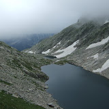
For some reason my feet decided to be unbelievably sore again, so I needed to stop and take ibuprofen to be able to walk properly without hobbling. My plan at this point was to stop at the Refuge at Col de l'Ouillat, but when I reached it I wasn't in the mood for sitting with noisy people smoking and drinking, so I didn't even break step, but marched straight past and onwards and upwards towards Pic Neulos. By this stage I was far more comfortable in my own company, and preferred to by high on a windswept hill with shards of light breaking through the oppressively dark sky.
It was quite exhilarating to be right at the summit of Pic Neulos in fading light, and in a blasting wind, and knowing that the only shelter was the unmanned bothy Refuge de la Tagnarede in another kilometre or so. I reached the bothy just before 9.30pm, and luckily the place was deserted. All night the wind slammed and rattled the roof, which gave the place a spooky atmosphere.
View HRP - Day 23 in a larger map
 |
| HRP - Day 23 |
I got up quietly to have a 6am breakfast with the Gite owner Laurent. There were a couple of other guys helping at the gite as part of the WWOOF project for developing organic farming. After a long leisurely breakfast, the other hikers were emerging. I managed to get going by 7am, but almost immediately reached a fork on the trail and took the wrong option. I should have taken the lefthand upper trail, but the lower track looked like the main route.
I followed this through a gate and up some switchbacks which I should have realised were heading the wrong way, when suddenly 2 dogs starting barking insanely and a guy came out of the farm I was trying to pass unnoticed. He looked at my map, and told me I was heading up the wrong hill. I tried to find my compass to confirm this, but he said a compass would be of now use. He told the only way to navigate these hills was to watch the sun, but then looked up and said "only there is no sun today". I thanked him as I turned around to head back down again, and he said "today I saved your life".
Soon I was back at the fork, and took the upper trail and found the small wooden sign pointing to "Roc de France" with blue marks. This was quite a fiddly trail that lead up to Col Cerda 1058m, which would have made a good camping spot. The trail then improved as it re-joined the GR10, but became quite fiddly again as I tried to follow the high ground over Roc de Frausa which had several rocky summits.
I took a short break once I reached the Refuge des Salines (briefly back in Spain), then followed forest tracks back to the border at Col de Lly for the short descent to Las Illas.
The section from Las Illas to Col du Perthus was mainly along forestry pistas, and with afternoon fatigue kicking in, it was quite hard to stay awake. It was after 4pm when I reached the grim border town of Le Perthus. This really is a place you want to get in and out of as quickly as possible. I grabbed a bagful of shopping from the first supermarket, and starting walking up the hill straightaway. The GR10 has recently be re-routed at this point to take you through rough scrubland, rather than hiking up the road. It would probably have been quicker to have walked up the road, since the marked trail took a pretty tortuous route.
For some reason my feet decided to be unbelievably sore again, so I needed to stop and take ibuprofen to be able to walk properly without hobbling. My plan at this point was to stop at the Refuge at Col de l'Ouillat, but when I reached it I wasn't in the mood for sitting with noisy people smoking and drinking, so I didn't even break step, but marched straight past and onwards and upwards towards Pic Neulos. By this stage I was far more comfortable in my own company, and preferred to by high on a windswept hill with shards of light breaking through the oppressively dark sky.
It was quite exhilarating to be right at the summit of Pic Neulos in fading light, and in a blasting wind, and knowing that the only shelter was the unmanned bothy Refuge de la Tagnarede in another kilometre or so. I reached the bothy just before 9.30pm, and luckily the place was deserted. All night the wind slammed and rattled the roof, which gave the place a spooky atmosphere.
View HRP - Day 23 in a larger map
Friday, July 22, 2011
Day 22 - Prat Cabrera to Gite Moulin de la Palette
22nd July 2011
Once again, up and away before daybreak to begin the long traverse around Pic du Canigou on the so-called 'Balcon du Canigou'. I started off my headtorch along the narrow greasy path. Within minutes my feet were sodden from dew-laden grass overhanging the trail.
After a couple of hours I suddenly arrived at the Maison Forestiere de l'Estanyol, where I took a break for a minutes from the cold misty dampness to sit inside. I then pushed on for another couple of hours to arrive at Gite Mines de Batere, quite tired and with sore wet feet. Once inside, the place had a lovely mellow atmosphere with quiet gentle music and a wood fire burning. A stayed for several cafe au laits before venturing back out into the dreich mist.
The descent to Arles-sur-Tech was fairly confusing down woodland trails, and more complex than it appeared on the map. I imagine this section is normally descending into scorching heat, but today it was pretty grey and overcast. I arrived in Arles just after 2pm, but the Spar supermarche was closed until 3pm, so had a few minutes to re-group, dispose of rubbish, re-tape toes etc.
The climb beyond Arles was back into dense forest that completely throws your sense of direction. I did have a vague plan to bivvy high on the Roc de Frausa, but when I arrived at Gite Moulin de la Palette just after 6pm, the place had such a nice welcoming atmosphere I immediately decided to stay. Plus it meant I could have my first shower and shave for quite a while to feel a bit more human again.
The evening turned out to be an enjoyable social affair, with 2 big tables for the evening meal followed by French-style guitar playing and singing.
View HRP - Day 22 in a larger map
 |
| HRP - Day 22 |
Once again, up and away before daybreak to begin the long traverse around Pic du Canigou on the so-called 'Balcon du Canigou'. I started off my headtorch along the narrow greasy path. Within minutes my feet were sodden from dew-laden grass overhanging the trail.
After a couple of hours I suddenly arrived at the Maison Forestiere de l'Estanyol, where I took a break for a minutes from the cold misty dampness to sit inside. I then pushed on for another couple of hours to arrive at Gite Mines de Batere, quite tired and with sore wet feet. Once inside, the place had a lovely mellow atmosphere with quiet gentle music and a wood fire burning. A stayed for several cafe au laits before venturing back out into the dreich mist.
The descent to Arles-sur-Tech was fairly confusing down woodland trails, and more complex than it appeared on the map. I imagine this section is normally descending into scorching heat, but today it was pretty grey and overcast. I arrived in Arles just after 2pm, but the Spar supermarche was closed until 3pm, so had a few minutes to re-group, dispose of rubbish, re-tape toes etc.
The climb beyond Arles was back into dense forest that completely throws your sense of direction. I did have a vague plan to bivvy high on the Roc de Frausa, but when I arrived at Gite Moulin de la Palette just after 6pm, the place had such a nice welcoming atmosphere I immediately decided to stay. Plus it meant I could have my first shower and shave for quite a while to feel a bit more human again.
The evening turned out to be an enjoyable social affair, with 2 big tables for the evening meal followed by French-style guitar playing and singing.
View HRP - Day 22 in a larger map
Thursday, July 21, 2011
Day 21 - Refuge Ulldeter to Prat Cabrera
21st July 2011
This morning I was up and away by 6am, keen to capitalise on the ground I made up yesterday, and with half a mind on reaching Gite Mines de Batere.
I saw a fantastic sunrise from the Col de la Marrana before dropping down to Refuge Ulldeter for some breakfast. The next long ridge section to Refuge de Mariailles looked pretty straightforward on the map, but turned out to be much tougher than expected, so I was fairly tired by the time I reached Marialles and stopped for half an hour of so for an omelette and some coffee.
It was super-misty as I left the refuge and very murky on the climb up Pic du Canigou. The final steep section was quite daunting in the cold windy conditions, with no view whatsoever from the deserted summit. I descended quite carefully down the rocky zig-zags that eventually lead out to Refuge des Cortalets.
The atmosphere around the refuge was so depressing with cold dank mist and water dripping off the trees, it did not appeal, and even though it was about to get dark, I still decided to hike on down the trail for an hour or so to find a solitary camping spot.
I reached the junction at Prat Cabrera where the narrow rocky 'Balcon du Canigou' footpath begins. This looked like a bad choice for camping spots, but managed to find a lumpy patch of level ground just below the junction, in tussocky wet grass that did the job.
View HRP - Day 21 in a larger map
 |
| HRP - Day 21 |
This morning I was up and away by 6am, keen to capitalise on the ground I made up yesterday, and with half a mind on reaching Gite Mines de Batere.
I saw a fantastic sunrise from the Col de la Marrana before dropping down to Refuge Ulldeter for some breakfast. The next long ridge section to Refuge de Mariailles looked pretty straightforward on the map, but turned out to be much tougher than expected, so I was fairly tired by the time I reached Marialles and stopped for half an hour of so for an omelette and some coffee.
It was super-misty as I left the refuge and very murky on the climb up Pic du Canigou. The final steep section was quite daunting in the cold windy conditions, with no view whatsoever from the deserted summit. I descended quite carefully down the rocky zig-zags that eventually lead out to Refuge des Cortalets.
The atmosphere around the refuge was so depressing with cold dank mist and water dripping off the trees, it did not appeal, and even though it was about to get dark, I still decided to hike on down the trail for an hour or so to find a solitary camping spot.
I reached the junction at Prat Cabrera where the narrow rocky 'Balcon du Canigou' footpath begins. This looked like a bad choice for camping spots, but managed to find a lumpy patch of level ground just below the junction, in tussocky wet grass that did the job.
View HRP - Day 21 in a larger map
Wednesday, July 20, 2011
Day 20 - Refuge des Besines to Refuge Ulldeter (almost)
20th July 2011
After a rather short 'recovery' day yesterday, I knew I had some catching up to do today. It is always more difficult to make an early start from a refuge, but I was away by 6:50am.
I had no intention of climbing Pic Carlit, so took the easier GR10 alternative to reach the Barrage des Bouillouses. A fantastically scenic and popular spot.
Next came a long section of trails through forest, where I was almost asleep on my feet, head nodding and walking like a drunkard. I just about maintained consciousness to arrive at Bolquere where my plan was to do a quick shop and then press on towards the hills beyond Eyne. However this plan was scuppered when I reached the shop at 2.15pm only to discover it wouldn't re-open until 4pm. My only option now was to visit the next door hotel, grab a decent meal and relax for the next 1.5 hours. Once the shop was open again, I bought a few more provisions then followed the road all the way to Eyne.
Having lost a couple of hours, my initial plan was to camp somewhere near the head of the Vallee d'Eyne, however I was making such good time, and keen to use the full daylight hours, so just kept going up to Col de Nuria 2683m, and by the time I reached Pic de Noufonts 2861m, it was just after 8pm so I knew I had just over an hour's daylight to complete the traverse above Nuria and find somewhere to camp. This helped to focus the mind, and to get a bit of a move on.
Luckily the wands were out for the Olla de Núria Sky Race, which made the route finding a bit easier in the failing light. Plus this section is also on the GR11, so I vaguely recognised the route from last year. I managed to descend to about 2400m and find a patch of flat ground and was in the tent by 9.45pm.
View HRP - Day 20 in a larger map
 |
| HRP - Day 20 |
After a rather short 'recovery' day yesterday, I knew I had some catching up to do today. It is always more difficult to make an early start from a refuge, but I was away by 6:50am.
I had no intention of climbing Pic Carlit, so took the easier GR10 alternative to reach the Barrage des Bouillouses. A fantastically scenic and popular spot.
Next came a long section of trails through forest, where I was almost asleep on my feet, head nodding and walking like a drunkard. I just about maintained consciousness to arrive at Bolquere where my plan was to do a quick shop and then press on towards the hills beyond Eyne. However this plan was scuppered when I reached the shop at 2.15pm only to discover it wouldn't re-open until 4pm. My only option now was to visit the next door hotel, grab a decent meal and relax for the next 1.5 hours. Once the shop was open again, I bought a few more provisions then followed the road all the way to Eyne.
Having lost a couple of hours, my initial plan was to camp somewhere near the head of the Vallee d'Eyne, however I was making such good time, and keen to use the full daylight hours, so just kept going up to Col de Nuria 2683m, and by the time I reached Pic de Noufonts 2861m, it was just after 8pm so I knew I had just over an hour's daylight to complete the traverse above Nuria and find somewhere to camp. This helped to focus the mind, and to get a bit of a move on.
Luckily the wands were out for the Olla de Núria Sky Race, which made the route finding a bit easier in the failing light. Plus this section is also on the GR11, so I vaguely recognised the route from last year. I managed to descend to about 2400m and find a patch of flat ground and was in the tent by 9.45pm.
View HRP - Day 20 in a larger map
Tuesday, July 19, 2011
Day 19 - Camping d'Incles to Refuge des Besines
19th July 2011
Having been sick in the night, I was feeling apprehensive this morning. My mood was not helped at 6am by the fact it was still pitch dark, pouring with rain and a full-on thunder storm was raging. I couldn't muster the enthusiasm to leave the shelter of the tent just yet, so re-inflated my thermarest, got back in my sleeping bag, and went back to sleep for an hour to let the worst of the storm pass.
At 7am, the rain was lighter so I leapt out of the tent, stripped it down and started splish sploshing up the soggy trail into the mist. It got really quite cold, rainy and unpleasant as I approached the Refuge de Juclar. I expected to have the place to myself so was surprised when I walked in to find about 30 school kids all looking like they'd had one heck of a party the night before.
Once more into the mist and rain, and I was soon over the Port l'Albe to leave Andorra for France. The descent was super rough and rocky, and played havoc with my sore toes. I stopped at the first big lake to try to dry my sodden shoes and re-tape my toes which were in a terrible state. A group of 3 French hikers suddenly appeared and we had a bit of a chat, before I got a move on for the descent to l'Hospitalet.
I was expecting some sort of shop at l'Hospitalet, but there was nothing open apart from the Hotel du Puymorens. I made myself comfortable in the vestibule, and ordered coffees & croissants and tried to get my shoes dried out, and re-taped my toes. Soon the 3 French hikers who I'd seen earlier appeared. We had some more chat and all decided to walk to the Refuge des Besines later in the afternoon. I had planned to go a bit further, but without any food, the staffed refuge seemed a better option.
The hike to the refuge was on easy graded trails and took just under 2 hours at a fairly rapid pace. This gave plenty of time for dossing around and recovering and for eating the most enormous amount of food during the evening meal. A good social evening.
View HRP - Day 19 in a larger map
 |
| HRP - Day 19 |
Having been sick in the night, I was feeling apprehensive this morning. My mood was not helped at 6am by the fact it was still pitch dark, pouring with rain and a full-on thunder storm was raging. I couldn't muster the enthusiasm to leave the shelter of the tent just yet, so re-inflated my thermarest, got back in my sleeping bag, and went back to sleep for an hour to let the worst of the storm pass.
At 7am, the rain was lighter so I leapt out of the tent, stripped it down and started splish sploshing up the soggy trail into the mist. It got really quite cold, rainy and unpleasant as I approached the Refuge de Juclar. I expected to have the place to myself so was surprised when I walked in to find about 30 school kids all looking like they'd had one heck of a party the night before.
Once more into the mist and rain, and I was soon over the Port l'Albe to leave Andorra for France. The descent was super rough and rocky, and played havoc with my sore toes. I stopped at the first big lake to try to dry my sodden shoes and re-tape my toes which were in a terrible state. A group of 3 French hikers suddenly appeared and we had a bit of a chat, before I got a move on for the descent to l'Hospitalet.
I was expecting some sort of shop at l'Hospitalet, but there was nothing open apart from the Hotel du Puymorens. I made myself comfortable in the vestibule, and ordered coffees & croissants and tried to get my shoes dried out, and re-taped my toes. Soon the 3 French hikers who I'd seen earlier appeared. We had some more chat and all decided to walk to the Refuge des Besines later in the afternoon. I had planned to go a bit further, but without any food, the staffed refuge seemed a better option.
The hike to the refuge was on easy graded trails and took just under 2 hours at a fairly rapid pace. This gave plenty of time for dossing around and recovering and for eating the most enormous amount of food during the evening meal. A good social evening.
View HRP - Day 19 in a larger map
Monday, July 18, 2011
Day 18 - Pla de Boet to Camping d'Incles
18th July 2011
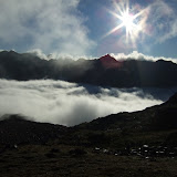
Once again I was up and away before daybreak. It was actually pretty cold this morning with frost on the ground as I hiked up to Port de Boet 2509m. I reached the pass just after sunrise, and was greeted with a stunning cloud inversion on the French side.
The descent was pretty rough as I descended into thick freezing fog to reach Etang de la Soucarrane. I was very glad I hadn't pressed on the night before, since this would have been a grim place to camp. The next section was more or less pathless and involved thrashing through tussocky wet grass and undergrowth to eventually pop out on a dirt road.
My shoes were now soaked and full of water, so I spent a few minutes wringing out my socks and trying to dry my shoes to some extent. It was much easier hiking now up to the Port de Rat 2540m which drops over into Andorra. Also the weather was brightening up, and there was an easy descent to La Coma bar/restaurant in El Serrat ski area. I took some time here to re-group and to dry my kit, taking over a couple of the tables.
It was still quite cold and windy despite the bright sunshine, but on the descent to El Serrat the temperature picked up, and for the first time in a few days it was actually warm and sunny. Before reaching El Serrat the road branches upwards and turns into a dirt track to reach Refugi de Sorteny. I stopped at the water point to re-fill, and to eat before pressing on through wonderful meadows full of alpine flowers.
The next section of trail lead easily to the Collada dels Meners 2713m, where I caught up with a Frenchman also hiking the HRP. We then hiked together as far as Cabana Coms de Jan, where he planned to stay the night. I thought I might be able to reach Refugi de Juclar, however the continuation trail had far more ascent than anticipated, so once I'd reached Cabana Sorda I decided to drop down into the valley to Camping d'Incles. This turned out to be a good plan as I found out later on.
Camping d'Incles was a grim and depressing spot with no facilities, but I found a small patch of grass good enough to pitch the tent. During the night I felt unwell and was sick, and was anxious that I'd got food poisoning.
View HRP - Day 18 in a larger map
 |
| HRP - Day 18 |
Once again I was up and away before daybreak. It was actually pretty cold this morning with frost on the ground as I hiked up to Port de Boet 2509m. I reached the pass just after sunrise, and was greeted with a stunning cloud inversion on the French side.
The descent was pretty rough as I descended into thick freezing fog to reach Etang de la Soucarrane. I was very glad I hadn't pressed on the night before, since this would have been a grim place to camp. The next section was more or less pathless and involved thrashing through tussocky wet grass and undergrowth to eventually pop out on a dirt road.
My shoes were now soaked and full of water, so I spent a few minutes wringing out my socks and trying to dry my shoes to some extent. It was much easier hiking now up to the Port de Rat 2540m which drops over into Andorra. Also the weather was brightening up, and there was an easy descent to La Coma bar/restaurant in El Serrat ski area. I took some time here to re-group and to dry my kit, taking over a couple of the tables.
It was still quite cold and windy despite the bright sunshine, but on the descent to El Serrat the temperature picked up, and for the first time in a few days it was actually warm and sunny. Before reaching El Serrat the road branches upwards and turns into a dirt track to reach Refugi de Sorteny. I stopped at the water point to re-fill, and to eat before pressing on through wonderful meadows full of alpine flowers.
The next section of trail lead easily to the Collada dels Meners 2713m, where I caught up with a Frenchman also hiking the HRP. We then hiked together as far as Cabana Coms de Jan, where he planned to stay the night. I thought I might be able to reach Refugi de Juclar, however the continuation trail had far more ascent than anticipated, so once I'd reached Cabana Sorda I decided to drop down into the valley to Camping d'Incles. This turned out to be a good plan as I found out later on.
Camping d'Incles was a grim and depressing spot with no facilities, but I found a small patch of grass good enough to pitch the tent. During the night I felt unwell and was sick, and was anxious that I'd got food poisoning.
View HRP - Day 18 in a larger map
Sunday, July 17, 2011
Day 17 - Graus to Pla de Boet
17th July 2011
Today I was up an away from the Graus campsite before daybreak, to re-join the HRP at Noarre by 7am. On the climb up to Coll de Certascan 2605m the weather wasn't looking too great, and I reached the Refugi de Certascan by 11am, just before it started absolutely chucking it down with rain.
It was quite comforting being inside sheltered from the elements, drinking coffee and having an early lunch. However I wasn't that keen about stepping outside again into the freezing pouring rain. Just after midday I braced myself to continue along the slippery rocky trail, in full waterproofs.
Luckily the rain soon eased, and I found a much better descent to Pla de Boavi than described in the guidebook. I simply followed red and white markers that dropped you into the valley a few hundred metres downstream of the large flat area occupied by schoolkids on a holiday camp.
My target for the afternoon was to see whether I could cross the Port de Boet back into France. The next section of trail was perfectly graded zig-zags through forest that made for rapid progress to the Coll de Sellente 2240m. The trail then got rougher past the Refugi de Cinquantenari, so it took a bit longer than expected to reach the Pla de Boet. It was now after 7pm, and I didn't fancy the 600m climb to Port de Boet so late in the day, so decided to camp at the furthest end of the Pla de Boet and enjoy the evening sunshine.
View HRP - Day 17 in a larger map
 |
| HRP - Day 17 |
Today I was up an away from the Graus campsite before daybreak, to re-join the HRP at Noarre by 7am. On the climb up to Coll de Certascan 2605m the weather wasn't looking too great, and I reached the Refugi de Certascan by 11am, just before it started absolutely chucking it down with rain.
It was quite comforting being inside sheltered from the elements, drinking coffee and having an early lunch. However I wasn't that keen about stepping outside again into the freezing pouring rain. Just after midday I braced myself to continue along the slippery rocky trail, in full waterproofs.
Luckily the rain soon eased, and I found a much better descent to Pla de Boavi than described in the guidebook. I simply followed red and white markers that dropped you into the valley a few hundred metres downstream of the large flat area occupied by schoolkids on a holiday camp.
My target for the afternoon was to see whether I could cross the Port de Boet back into France. The next section of trail was perfectly graded zig-zags through forest that made for rapid progress to the Coll de Sellente 2240m. The trail then got rougher past the Refugi de Cinquantenari, so it took a bit longer than expected to reach the Pla de Boet. It was now after 7pm, and I didn't fancy the 600m climb to Port de Boet so late in the day, so decided to camp at the furthest end of the Pla de Boet and enjoy the evening sunshine.
View HRP - Day 17 in a larger map
Saturday, July 16, 2011
Day 16 - Estany d'Airoto to Bordes de Graus
16th July 2011
I was keen to get away early to find some water, so my alarm was set for 5am. However when I was ready to leave at 5.40am it was still virtually pitch dark, so I delayed a few minutes before setting off by headtorch at first.
It was relief to descend from the Collada del Clot de Moredo to La Basseta to find a stream that was strangely disappearing straight into the hillside. I felt much better after a good drink, but then made a few bad route choices on the descent to Alos d'Isil and ended up taking the long way round on a rather tortuous dirt track. I took a good break at Alos d'Isil to eat and refill my water bottle.
After Alos d'Isil was pleasant section of road beside a sparkling river, before turning off for a steep wooded climb that eventually lead steeply to the Coll de la Cornella 2485m.
The following section to Refugi Enric Pujol was through rugged landscape scattered with mountain lakes. I stopped for a few minutes at the Refuge - the small metal box type - to chat with an English/New Zealand couple. When I mentioned how little food I was carrying, these suggested the detour to Bordes de Graus Camping. This seemed like quite an appealing option to get a proper meal. My orginal plan had been to continue to Noarre and beyond, but there was no way I could reach Refugi de Certascan today, so I decided to drop down to Graus.
The campsite was relaxing with good food, however it was the only time in the whole that I was really savaged by mosquitoes.
View HRP - Day 16 in a larger map
 |
| HRP - Day 16 |
I was keen to get away early to find some water, so my alarm was set for 5am. However when I was ready to leave at 5.40am it was still virtually pitch dark, so I delayed a few minutes before setting off by headtorch at first.
It was relief to descend from the Collada del Clot de Moredo to La Basseta to find a stream that was strangely disappearing straight into the hillside. I felt much better after a good drink, but then made a few bad route choices on the descent to Alos d'Isil and ended up taking the long way round on a rather tortuous dirt track. I took a good break at Alos d'Isil to eat and refill my water bottle.
After Alos d'Isil was pleasant section of road beside a sparkling river, before turning off for a steep wooded climb that eventually lead steeply to the Coll de la Cornella 2485m.
The following section to Refugi Enric Pujol was through rugged landscape scattered with mountain lakes. I stopped for a few minutes at the Refuge - the small metal box type - to chat with an English/New Zealand couple. When I mentioned how little food I was carrying, these suggested the detour to Bordes de Graus Camping. This seemed like quite an appealing option to get a proper meal. My orginal plan had been to continue to Noarre and beyond, but there was no way I could reach Refugi de Certascan today, so I decided to drop down to Graus.
The campsite was relaxing with good food, however it was the only time in the whole that I was really savaged by mosquitoes.
View HRP - Day 16 in a larger map
Friday, July 15, 2011
Day 15 - Estany deth Cap deth Port to Estany d'Airoto
15th July 2011
The next day, thankfully my ankle was OK... I was away from Estany deth Cap deth Port at daybreak, slightly nervous about reaching the Salardu shop before siesta. The initial section was on vaguely familiar terrain having hiked this during the GR11 last year. At Refuge Colomers I peeled off northwards at the dam to descend a nice broad valley. Luckily I reached Salardu at about 12.50pm with the shop closing at 1.15pm. I grabbed some food, and also bought some more strapping and ibuprofen at the pharmacy. Whilst re-packing I lost patience with lugging around the Kahtoola Microspikes, so left them behind under the bench.
I grabbed a quick plate of pasta before setting off on the afternoon shift. Initially the route appeared to be heading in completely the wrong direction, but in fact picked up a nice shaded trail through the woods before hitting dirt roads up to the vast skiiing area covered with grazing horses. The climb continued steadily past a few lakes until I suddenly bumped into Rick DeLong coming the other way. We had corresponded by email beforehand, so it was good to meet in person. Rick had already thru-hiked the PCT so knew all about travelling light, and had a pack way lighter than mine. We chatted for half an hour before heading our separate ways. I was a bit anxious now that it was getting late as I flogged steeply up Tuc Something. A pretty dramatic rocky summit. The continuation along the ridge was seriously rocky and slow-going.
I eventually reached the Coll d'Airoto and my plan was to drop to the Refuge d'Airoto which has a water source, but I made the mistake of trying to go around the lake on the north-eastern side which turned out to be an horrific boulder field that was wearing on the nerves and time-consuming. So I kind of ran out of time to get to the refuge and instead just wind-camped high above the lake on the first bit of flat ground I could find. This meant I had very little water for the night which wasn't ideal.
View HRP - Day 15 in a larger map
 |
| HRP - Day 15 |
The next day, thankfully my ankle was OK... I was away from Estany deth Cap deth Port at daybreak, slightly nervous about reaching the Salardu shop before siesta. The initial section was on vaguely familiar terrain having hiked this during the GR11 last year. At Refuge Colomers I peeled off northwards at the dam to descend a nice broad valley. Luckily I reached Salardu at about 12.50pm with the shop closing at 1.15pm. I grabbed some food, and also bought some more strapping and ibuprofen at the pharmacy. Whilst re-packing I lost patience with lugging around the Kahtoola Microspikes, so left them behind under the bench.
I grabbed a quick plate of pasta before setting off on the afternoon shift. Initially the route appeared to be heading in completely the wrong direction, but in fact picked up a nice shaded trail through the woods before hitting dirt roads up to the vast skiiing area covered with grazing horses. The climb continued steadily past a few lakes until I suddenly bumped into Rick DeLong coming the other way. We had corresponded by email beforehand, so it was good to meet in person. Rick had already thru-hiked the PCT so knew all about travelling light, and had a pack way lighter than mine. We chatted for half an hour before heading our separate ways. I was a bit anxious now that it was getting late as I flogged steeply up Tuc Something. A pretty dramatic rocky summit. The continuation along the ridge was seriously rocky and slow-going.
I eventually reached the Coll d'Airoto and my plan was to drop to the Refuge d'Airoto which has a water source, but I made the mistake of trying to go around the lake on the north-eastern side which turned out to be an horrific boulder field that was wearing on the nerves and time-consuming. So I kind of ran out of time to get to the refuge and instead just wind-camped high above the lake on the first bit of flat ground I could find. This meant I had very little water for the night which wasn't ideal.
View HRP - Day 15 in a larger map
Thursday, July 14, 2011
Day 14 - Hospital de Benasque to Estany deth Cap deth Port
14th July 2011
After my `rest day´ at Hospital de Benasque, it was time to get going again on 14th July. I met the Czech folk after about an hour before the climbing started up towards the Coll de Molleres. It was still pretty misty and dank and not easy to follow the route. Luckily just before the col, the mist suddenly enough to see where the col was. The descent down the other side was seriously steep to start with, but quickly backed off to a sea of boulders. The descent was so long and rough that after a while the tendons in my left ankle were screaming in complaint. Eventually I was scarcely moving and just hobbling along, so I needed to stop and tape my ankle.
When I reached the valley floor near Hospital de Vielha, I stuck my foot in the river for 15 minutes, and re-taped the ankle before continuing again. I chatted with a nice French couple who were about to hitch through the tunnel for supplies at Vielha, and they persuaded me to take some ibuprofen and carry on. So I began the next stage in reached the Restance Refuge pretty late, but just walked straight past and made a higher bivouac beside the Estany deth Cap deth Port.
View HRP - Day 14 in a larger map
 |
| HRP - Day 14 |
After my `rest day´ at Hospital de Benasque, it was time to get going again on 14th July. I met the Czech folk after about an hour before the climbing started up towards the Coll de Molleres. It was still pretty misty and dank and not easy to follow the route. Luckily just before the col, the mist suddenly enough to see where the col was. The descent down the other side was seriously steep to start with, but quickly backed off to a sea of boulders. The descent was so long and rough that after a while the tendons in my left ankle were screaming in complaint. Eventually I was scarcely moving and just hobbling along, so I needed to stop and tape my ankle.
When I reached the valley floor near Hospital de Vielha, I stuck my foot in the river for 15 minutes, and re-taped the ankle before continuing again. I chatted with a nice French couple who were about to hitch through the tunnel for supplies at Vielha, and they persuaded me to take some ibuprofen and carry on. So I began the next stage in reached the Restance Refuge pretty late, but just walked straight past and made a higher bivouac beside the Estany deth Cap deth Port.
View HRP - Day 14 in a larger map
Wednesday, July 13, 2011
Day 13 - Hospital de Benasque
13th July 2011
Day 13 turned out to be a bit of a wash out. I had stayed the night at Hospital de Benasque, but the forecast for today was grim, with rain and low cloud all day.
Despite the lousy forecast I got up early, packed my rucksack, and took breakfast at 6am. Around 6.30am I looked outside and saw that it was pouring with rain, with low cloud. The prospect of crossing the Coll de Mulleres 2928m in these conditions was not appealing, so I decided to write off the day and use it to regroup for tomorrow.
I jumped on a bus down to Benasque and mooched around the shops for a few hours, and wrote up these comments. When I returned to the hotel mid-afternoon the 4 Czech hikers I'd seen yesterday at Refuge de Portillon had just arrived, having spent an exciting wild camp in the massive hailstorm last night. We all had some coffee together before they wandered off into the mist and rain to find a camping spot.
 |
| HRP - Day 13 |
Day 13 turned out to be a bit of a wash out. I had stayed the night at Hospital de Benasque, but the forecast for today was grim, with rain and low cloud all day.
Despite the lousy forecast I got up early, packed my rucksack, and took breakfast at 6am. Around 6.30am I looked outside and saw that it was pouring with rain, with low cloud. The prospect of crossing the Coll de Mulleres 2928m in these conditions was not appealing, so I decided to write off the day and use it to regroup for tomorrow.
I jumped on a bus down to Benasque and mooched around the shops for a few hours, and wrote up these comments. When I returned to the hotel mid-afternoon the 4 Czech hikers I'd seen yesterday at Refuge de Portillon had just arrived, having spent an exciting wild camp in the massive hailstorm last night. We all had some coffee together before they wandered off into the mist and rain to find a camping spot.
Hendaye to Hospital de Benasque
My HRP hike began at about 6pm on Friday 1st July at Hendaye beach, shortly after stepping off the bus into searing heat, and feeling a bit of an idiot carrying an ice axe whilst mingling with surfers in swimwear.
Day 1 - Hendaye to Col d´Ibardin (almost)
My first day was a 3 hour evening hike out of Hendaye, and getting a bit lost, but eventually finding my way up onto the ridge just before Col d´Ibardin, where I bivvied near some horses.
Day 2 - Col d´Ibardin to Col Basabar
This was the only day so far I´ve met any other HRP hikers, and I was caught by both of them. A French guy called Claude, who was aiming for an 18 day traverse, and a Dutchman called Robin who had a more conservative schedule.
Day 3 - Col Basabar to Azpegi Cabane
Starting raining late in the day, so dived down off the HRP to find the Azpegi Cabane. A very large clean bothy that I had to myself.
Day 4 - Azpegi Cabane to Port de Larrau
Super sore feet today. Tremendous hike over Pic d´Orhly in the evening.
Day 5 - Port de Larrau to Source de Marmitou
Another day of mind-boggling foot pain. Super tough afternoon section through karst country with no water.
Day 6 - Source de Marmitou to Col du Somport
A good long day, where I felt like I was covering the ground a bit better. Dropped down to Lescun for food and coffee, before long climb up to super ridge walk above the clouds. Got lost near the end and had to hike up the road to Col du Somport where I met Trevor and Nicki for a much needed meal.
Day 7 - Col du Somport to Refuge Arremoulit
Trevor came out with me for the first couple of hours before heading back. I then had a great hike around the Pic Midi d´Ossau to Refuge Pombie. On the descent to the road, I stupidly dropped my map, but luckily realised in time, so only need to sprint back up for 5 minutes to retrieve. A fun evening at Refuge Arremoulit with a bunch of young Spanish hikers.
Day 8 - Refuge Arremoulit to Oulettes de Gaube
Some tremendous scenery today. Hiked over to Respomuso, then over Col du Grand Fache to Refuge Wallon, before another huge flog up and over to Oulettes de Gaube to bivvy below the Vignemale.
Day 9 - Oulettes de Gaube to Heas
I was hiking at 6.10am, since I knew this would be a long day. It was cold and windy heading over the Hourquette de Oulettes, then very busy on the trail down to Gavarnie. At Garvanie the heat was stifling and it took a while to get sorted for the 1100m climb to Hourquette d´Alans. The descent on the other side seemed to go on for ever just to reach the barage, and then there was another long road section to reach Heas. I can´t remember ever being so tired and then end of a hike. Luckily I found the wonderful Refuge d´Auberge and had a really comfortable night´s sleep.
Day 10 - Heas to Paso de los Caballos
The 10 hour hike to Parzan was a piece of cake compared with yesterday´s hike. I arrived at the Parzan petrol station in time to get a meal and watch the end of Stage 9 of Tour de France. After chatting with an English hiker called Ian, I hiked up the GR11 trail towards Paso de los Caballos, and bivvied just below the col.
Day 11 - Paso de los Caballos to Lac des Isclots
This was a moderately tough hike. GR11 down to Biados, then some pretty wild country to get to Refuge de la Soula. I stopped for a coke before continuing up a wild rocky trail to Lac du Isclots at 2400m, where I was surprised to see another tent.
Day 12 - Lac des Isclots to Hospital de Benasque
Definitely the roughest toughest stage so far. I teamed up with the French hiker to cross the high passes to Lac du Portillon, but then was on my own for the Col Literole Infernale, the highest on the route with a steep snowy scary descent on the far side. I was very glad of my ice axe now. The hike out to Hospital de Benasque was unbelievably rough and tortuous, and rain and hail storm hit for the final hour, so I was pretty we when I arrived.
This morning I had breakfast at 6am and planned to continue over the 2928m Coll de Mulleres to Hospital de Vielha, but it was pouring down with low cloud and forecast to rain all day. I didn´t fancy wasting a good stage by hiking in cloud and rain all day, so decided somewhat reluctantly to take the day off and fester in Benasque. I´m hoping that recharging the batteries for a day may have a beneficial effect in that I´ll feel a bit fresher when I set off tomorrow.
Tuesday, July 12, 2011
Day 12 - Lac des Isclots to Hospital de Benasque
12th July 2011
Probably the toughest, and certainly the most daunting day of the route so far. This is where the Haute Route really earns its name and reputation, by passing through some of the highest and wildest territory in the Pyrenees.
I was quite glad of some company when I teamed up with a young French guy who'd also been camping beside Lac des Isclots. We hiked together up the snow slopes to Col des Gourgs-Blancs 2877m, and met another couple of Frenchmen right on the col travelling in the opposite direction.
There was a fair bit of snow and some rocky patches to negotiate to get across to the Col du Pluviometre 2860m. We climbed up to the rain gauge just above the pass, but then I made a bit of a mistake by aiming straight towards Lac du Portillon without checking the map or guidebook. I got almost down to the hut before I realised that there was a massive crag and deep canyon blocking the passage, so I needed to climb most of the way back up again, which was a bit frustrating. However it made me realise that you should never attempt short cuts in the Pyrenees.
At took a break at the Refuge du Portillon for about half an hour, before heading back out for the 400m climb to the notorious Col Inferieur de Literole which at 2983m is the highest point on the haute route. It also has the most daunting descent on the other side, with a large steep permanent snowfield. This is the reason I'd been carrying an ice axe for the past 11 days, and I was certainly glad of it as I stepped out onto the steep snow. I teetered away rightwards (facing in) using the shallow footsteps and planting the axe firmly. Once the trail switched back, the angle quickly eased and I could turn to face outwards and semi-glissade the rest of the slope.
I tried to stay on the snow for as long as possible to get across to the Portal de Remune a bit quicker, and then began the really tough and rocky descent into the Valle de Remune. It was not easy going and the weather was starting to look pretty unsettled. As I got lower it started really hammering down with rain and hail, with thunder rumbling around the peaks.
I slithered and almost jogged down through the forest and tree roots to try to reach the road a bit faster. Once onto the road there was a shortcut across pastures to reach the Hospital de Benasque. It didn't take long to decide to check in for the night, and enjoy the luxury of a proper bed and shower, and listen to the storm from the comfort of my hotel room.
View HRP - Day 12 in a larger map
 |
| HRP - Day 12 |
Probably the toughest, and certainly the most daunting day of the route so far. This is where the Haute Route really earns its name and reputation, by passing through some of the highest and wildest territory in the Pyrenees.
I was quite glad of some company when I teamed up with a young French guy who'd also been camping beside Lac des Isclots. We hiked together up the snow slopes to Col des Gourgs-Blancs 2877m, and met another couple of Frenchmen right on the col travelling in the opposite direction.
There was a fair bit of snow and some rocky patches to negotiate to get across to the Col du Pluviometre 2860m. We climbed up to the rain gauge just above the pass, but then I made a bit of a mistake by aiming straight towards Lac du Portillon without checking the map or guidebook. I got almost down to the hut before I realised that there was a massive crag and deep canyon blocking the passage, so I needed to climb most of the way back up again, which was a bit frustrating. However it made me realise that you should never attempt short cuts in the Pyrenees.
At took a break at the Refuge du Portillon for about half an hour, before heading back out for the 400m climb to the notorious Col Inferieur de Literole which at 2983m is the highest point on the haute route. It also has the most daunting descent on the other side, with a large steep permanent snowfield. This is the reason I'd been carrying an ice axe for the past 11 days, and I was certainly glad of it as I stepped out onto the steep snow. I teetered away rightwards (facing in) using the shallow footsteps and planting the axe firmly. Once the trail switched back, the angle quickly eased and I could turn to face outwards and semi-glissade the rest of the slope.
I tried to stay on the snow for as long as possible to get across to the Portal de Remune a bit quicker, and then began the really tough and rocky descent into the Valle de Remune. It was not easy going and the weather was starting to look pretty unsettled. As I got lower it started really hammering down with rain and hail, with thunder rumbling around the peaks.
I slithered and almost jogged down through the forest and tree roots to try to reach the road a bit faster. Once onto the road there was a shortcut across pastures to reach the Hospital de Benasque. It didn't take long to decide to check in for the night, and enjoy the luxury of a proper bed and shower, and listen to the storm from the comfort of my hotel room.
View HRP - Day 12 in a larger map
Monday, July 11, 2011
Day 11 - Paso de los Caballos to Lac des Isclots
11th July 2011
The Paso de los Caballos was a cold windy cheerless place so early in the morning. The descent to Biados was all fairly familiar after last year's GR11. I was keen to check out the facilities at Camping Forcallo, since I'd just walked straight past last time. There was in fact a very clean and functional bar/restaurant where I took a break for at least half an hour to re-group.
I took the lower road to miss out Refugio de Biados, and then hiked up the Valle de Anescruzes through lush meadows of alpine flowers. I stopped above the meeting of the waters where the HRP breaks away from the GR11, and doused my feet in the river for a while.
The climb to the Port d'Aygues-Tortes was quite steep and dramatic, and the descent down the other side to Vallon d'Aygue-Tortes was pretty tortuous down boulder fields.
The walk down to Refuge de la Soula was bit tougher and more awkward than it appeared on the map, so I was fairly tired when I finally arrived just after 5.30pm. I bought a cheese sandwich and can of coke and contemplated staying, but the place did not have a nice atmosphere about it, and of course there were still 4 hours more daylight, so staying put was not really an option.
After a brief rest I hoisted the pack back on and launched back onto the trail with just over 700 metres to climb to reach the Lac des Isclots set in a thoroughly wild and dramatic mountain landscape.
View HRP - Day 11 in a larger map
 |
| HRP - Day 11 |
The Paso de los Caballos was a cold windy cheerless place so early in the morning. The descent to Biados was all fairly familiar after last year's GR11. I was keen to check out the facilities at Camping Forcallo, since I'd just walked straight past last time. There was in fact a very clean and functional bar/restaurant where I took a break for at least half an hour to re-group.
I took the lower road to miss out Refugio de Biados, and then hiked up the Valle de Anescruzes through lush meadows of alpine flowers. I stopped above the meeting of the waters where the HRP breaks away from the GR11, and doused my feet in the river for a while.
The climb to the Port d'Aygues-Tortes was quite steep and dramatic, and the descent down the other side to Vallon d'Aygue-Tortes was pretty tortuous down boulder fields.
The walk down to Refuge de la Soula was bit tougher and more awkward than it appeared on the map, so I was fairly tired when I finally arrived just after 5.30pm. I bought a cheese sandwich and can of coke and contemplated staying, but the place did not have a nice atmosphere about it, and of course there were still 4 hours more daylight, so staying put was not really an option.
After a brief rest I hoisted the pack back on and launched back onto the trail with just over 700 metres to climb to reach the Lac des Isclots set in a thoroughly wild and dramatic mountain landscape.
View HRP - Day 11 in a larger map
Sunday, July 10, 2011
Day 10 - Héas to Parzan (and a bit further)
10th July 2011
I was very glad about staying the Auberge Le Refuge barn, since there appeared to have been a big storm in the night. I was keen to get going, but thought I might as well grab some breakfast and coffee at the Auberge, so it was a bit of a slow start.
The first climb of the day was around 1100 metres to the Hourquette de Héas 2608m which was quite a spectacular rocky slot in a ridge. There was another drop and climb to the Hourquette de Chermentas before a long contour around to the Refuge de Barroude where I took 5 minutes to lie down and eat something.
A short easy climb over the Port de Barroude and I was back into Spain. Somehow I always find the Spanish less edgy and threatening, so it was a relief to be descending towards Parzan. The last 5km section down the main road dragged on a bit, especially with the temperature rocketing upwards. By the time I reached the petrol station at Parzan, it was a relief to get out of the scorching sun and into an air conditioned bar/restaurant. I ordered biftec y frites, and took in the last 20 minutes of Stage 9 of the Tour de France with the 3-man breakaway that put Thomas Voeckler in yellow for 10 days.
After my tasty snack, I bought a few snacks and then hiked back up the road to the GR11 turn off which leads up a dirt road past a hydroelectric station to Paso de los Caballos. I hiked up here for a couple of hours until just below the pass, where I bivvied at around 2200 metres in a rather wild desolate landscape.
View HRP - Day 10 in a larger map
 |
| HRP - Day 10 |
I was very glad about staying the Auberge Le Refuge barn, since there appeared to have been a big storm in the night. I was keen to get going, but thought I might as well grab some breakfast and coffee at the Auberge, so it was a bit of a slow start.
The first climb of the day was around 1100 metres to the Hourquette de Héas 2608m which was quite a spectacular rocky slot in a ridge. There was another drop and climb to the Hourquette de Chermentas before a long contour around to the Refuge de Barroude where I took 5 minutes to lie down and eat something.
A short easy climb over the Port de Barroude and I was back into Spain. Somehow I always find the Spanish less edgy and threatening, so it was a relief to be descending towards Parzan. The last 5km section down the main road dragged on a bit, especially with the temperature rocketing upwards. By the time I reached the petrol station at Parzan, it was a relief to get out of the scorching sun and into an air conditioned bar/restaurant. I ordered biftec y frites, and took in the last 20 minutes of Stage 9 of the Tour de France with the 3-man breakaway that put Thomas Voeckler in yellow for 10 days.
After my tasty snack, I bought a few snacks and then hiked back up the road to the GR11 turn off which leads up a dirt road past a hydroelectric station to Paso de los Caballos. I hiked up here for a couple of hours until just below the pass, where I bivvied at around 2200 metres in a rather wild desolate landscape.
View HRP - Day 10 in a larger map
Saturday, July 9, 2011
Day 9 - Oulettes du Vignemale to Héas
9th July 2011
I knew this was going to be a long tough day, so the alarm was set for 5am, and I was hiking up the hill towards Hourquette d'Ossoue by 5.50. It was pretty cold and grey and windy, so I didn't hang around much, and just went straight past the Refuge de Baysellance without stopping.
Being a Saturday, the trail was super busy with folk hiking up kitted out with axe and crampons, until I got down to the Barrage d'Ossoue. I had a few minutes slumping on the grass, before heading on down the road to Gavarnie. I'd already hiked the GR10 that winds around the opposite hillside and knew that the road option would be much quicker.
At 12.30pm I arrived in Gavarnie, once again slightly nervous about whether any food shops would be open. Thankfully the supermarket is open all day, so I stocked up with what I could carry for the next couple of days.
Gavarnie is a funny place. Full of touristical kitsch, and paying homage to another era. You'll find plenty of hotels, camper vans and donkey rides. But I just wanted to find the quickest way back out onto the trail.
I remember at this point an American lady saying to me "Gee, looks like you've had quite a work out", but I was too tired and focused to be able to respond.
I started hiking towards the Cirque de Gavarnie, but the route then turns sharp left and launches into zig-zags up towards the Refuge des Espuguettes. There were quite a few day hikers around, but once I climbed further and crossed the Hourquette d'Alans 2430m, I was back on my own.
The next section reminded me of the Mull leg of the Scottish Islands Peaks Race where you hit a never ending descending traverse into a long valley, that just goes on and on. There was nobody around and just a few staring cattle, so it was quite a relief when the strangely green Lac des Gloriettes finally came into view.
I kept on seeing perfect camping spots, but knew I needed to keep pressing on towards Héas. After the dam on the lake, there was a rather grim road section leading down zig-zags into a gloomy steep-sided valley. I finally arrived in Héas at about 9pm, so was feeling moderately shattered after a long day. The so-called "Auberge Le Refuge" turned out the perfect place to stay. They served me omelette and fried potatoes with salad, and had a barn full of comfortable beds making for a great night's sleep.
View HRP - Day 9 in a larger map
 |
| HRP - Day 9 |
I knew this was going to be a long tough day, so the alarm was set for 5am, and I was hiking up the hill towards Hourquette d'Ossoue by 5.50. It was pretty cold and grey and windy, so I didn't hang around much, and just went straight past the Refuge de Baysellance without stopping.
Being a Saturday, the trail was super busy with folk hiking up kitted out with axe and crampons, until I got down to the Barrage d'Ossoue. I had a few minutes slumping on the grass, before heading on down the road to Gavarnie. I'd already hiked the GR10 that winds around the opposite hillside and knew that the road option would be much quicker.
At 12.30pm I arrived in Gavarnie, once again slightly nervous about whether any food shops would be open. Thankfully the supermarket is open all day, so I stocked up with what I could carry for the next couple of days.
Gavarnie is a funny place. Full of touristical kitsch, and paying homage to another era. You'll find plenty of hotels, camper vans and donkey rides. But I just wanted to find the quickest way back out onto the trail.
I remember at this point an American lady saying to me "Gee, looks like you've had quite a work out", but I was too tired and focused to be able to respond.
I started hiking towards the Cirque de Gavarnie, but the route then turns sharp left and launches into zig-zags up towards the Refuge des Espuguettes. There were quite a few day hikers around, but once I climbed further and crossed the Hourquette d'Alans 2430m, I was back on my own.
The next section reminded me of the Mull leg of the Scottish Islands Peaks Race where you hit a never ending descending traverse into a long valley, that just goes on and on. There was nobody around and just a few staring cattle, so it was quite a relief when the strangely green Lac des Gloriettes finally came into view.
I kept on seeing perfect camping spots, but knew I needed to keep pressing on towards Héas. After the dam on the lake, there was a rather grim road section leading down zig-zags into a gloomy steep-sided valley. I finally arrived in Héas at about 9pm, so was feeling moderately shattered after a long day. The so-called "Auberge Le Refuge" turned out the perfect place to stay. They served me omelette and fried potatoes with salad, and had a barn full of comfortable beds making for a great night's sleep.
View HRP - Day 9 in a larger map
Friday, July 8, 2011
Day 8 - Refuge d'Arremoulit to Oulettes du Vignemale
8th July 2011
Breakfast at 6am, then a rough rocky scramble up and over the Col d'Arremoulit to enter Spain for the first of four border crossings today. It was quite wild and bouldery beside the Lacs d'Arrie, so I was glad I hadn't continued last night. An icy river crossing gave me the first use of my ice axe to maintain balance. The views as you turn the corner towards the Embalse de Respumoso and surrounding hills are quite stunning, and difficult to stop photographing.
Once I reached the lake I was briefly back on the GR11 along past the Refugio, but then parted company again to aim towards the Col de la Fache 2664m, which had a few old snow patches but nothing too steep. Once over the col I was back into France on the descent to Refuge Wallon which I'd visited with Ellie in 2008. It's a beautiful place to relax with its sparkling rapids and cascades.
After a short break, lazing beside the river and re-taping my toes, I set off on the next big climb to Col d'Arratille 2528m which crosses back into Spain and overlooks the head of the Valle de Ara which leads down to Torla. It was getting fairly late, so you never see any other hikers on the hill at this time in the evening.
Once over the col, the track winds around a steep slope on a contour to reach the Col des Mulets which crosses back into France with a very steep descent down to the Oulettes du Vignemale, where I've always wanted to pitch my tent beneath the dramatic north face of the Vignemale.
View HRP - Day 8 in a larger map
 |
| HRP - Day 8 |
Breakfast at 6am, then a rough rocky scramble up and over the Col d'Arremoulit to enter Spain for the first of four border crossings today. It was quite wild and bouldery beside the Lacs d'Arrie, so I was glad I hadn't continued last night. An icy river crossing gave me the first use of my ice axe to maintain balance. The views as you turn the corner towards the Embalse de Respumoso and surrounding hills are quite stunning, and difficult to stop photographing.
Once I reached the lake I was briefly back on the GR11 along past the Refugio, but then parted company again to aim towards the Col de la Fache 2664m, which had a few old snow patches but nothing too steep. Once over the col I was back into France on the descent to Refuge Wallon which I'd visited with Ellie in 2008. It's a beautiful place to relax with its sparkling rapids and cascades.
After a short break, lazing beside the river and re-taping my toes, I set off on the next big climb to Col d'Arratille 2528m which crosses back into Spain and overlooks the head of the Valle de Ara which leads down to Torla. It was getting fairly late, so you never see any other hikers on the hill at this time in the evening.
Once over the col, the track winds around a steep slope on a contour to reach the Col des Mulets which crosses back into France with a very steep descent down to the Oulettes du Vignemale, where I've always wanted to pitch my tent beneath the dramatic north face of the Vignemale.
View HRP - Day 8 in a larger map
Thursday, July 7, 2011
Day 7 - Col du Somport to Refuge d'Arremoulit
7th July 2011
After all the drama and excitement of reaching Col du Somport last night, it was quite hard to get going this morning, not helped by the unbelievable pain in my feet, like somebody smashing my toes with a hammer at every footstep.
Luckily the body and mind can only tolerate so much pain before eventually blotting it out, and half forgetting about it, but only if you keep moving. Therefore Trevor and I trudged up towards the deserted ski area of Astun for the climb to Col de Moines which leads back into France, with stunning views of mist swirling around Pic du Midi d'Ossau.
Trevor continued for another half hour or so before legging it back to Col du Somport, whilst I continued on towards Refuge de Pombie, which I'd last visited with Jeff Knight back in 1999. I stopped for an omelette for lunch before heading down the hill to Caillou de Soques. After a few minutes I was overheating, so put away my pertex top. Then in another 5 minutes or so I suddenly realised I didn't have my map any more. In a bit of a panic I ditched my rucksack and raced back up the hill. Luckily the map was sitting on the ground, and I could jog back down and continue as before. However, without the map it would have been difficult to carry on.
Having dodged this bullet, I vowed to be more careful in future. At the bottom of the descent I was back in thick fog, and really needed the map and description to locate the trail back up to Col d'Arrious. After the col was an exciting section known as the Passage d'Orteig protected by a handrail across a steep section.
A short rough rocky descent lead to the Refuge d'Arremoulit in a truly dramatic mountainous setting perch on the edge of a glacial lake. It was not all that late, but the prospect of continuing and bivvying in a wild rocky wilderness didn't seem that appealing, compared with a comfortable social evening in the refuge. So I checked in and went for a lie down whilst waiting for the evening meal.
View HRP - Day 7 in a larger map
 |
| HRP - Day 7 |
After all the drama and excitement of reaching Col du Somport last night, it was quite hard to get going this morning, not helped by the unbelievable pain in my feet, like somebody smashing my toes with a hammer at every footstep.
Luckily the body and mind can only tolerate so much pain before eventually blotting it out, and half forgetting about it, but only if you keep moving. Therefore Trevor and I trudged up towards the deserted ski area of Astun for the climb to Col de Moines which leads back into France, with stunning views of mist swirling around Pic du Midi d'Ossau.
Trevor continued for another half hour or so before legging it back to Col du Somport, whilst I continued on towards Refuge de Pombie, which I'd last visited with Jeff Knight back in 1999. I stopped for an omelette for lunch before heading down the hill to Caillou de Soques. After a few minutes I was overheating, so put away my pertex top. Then in another 5 minutes or so I suddenly realised I didn't have my map any more. In a bit of a panic I ditched my rucksack and raced back up the hill. Luckily the map was sitting on the ground, and I could jog back down and continue as before. However, without the map it would have been difficult to carry on.
Having dodged this bullet, I vowed to be more careful in future. At the bottom of the descent I was back in thick fog, and really needed the map and description to locate the trail back up to Col d'Arrious. After the col was an exciting section known as the Passage d'Orteig protected by a handrail across a steep section.
A short rough rocky descent lead to the Refuge d'Arremoulit in a truly dramatic mountainous setting perch on the edge of a glacial lake. It was not all that late, but the prospect of continuing and bivvying in a wild rocky wilderness didn't seem that appealing, compared with a comfortable social evening in the refuge. So I checked in and went for a lie down whilst waiting for the evening meal.
View HRP - Day 7 in a larger map
Wednesday, July 6, 2011
Day 6 - Source de Marmitou to Col du Somport
6th July 2011
Day 6, and my aim for the day was to see if I could reach Candanchu and rendezvous with Trevor Richens. The day started with a descent into freezing fog and pretty murky conditions all the way down to Lescun.
Lescun was a much greyer, duller place than I was expecting, but luckily it had an open supermarket and hotel next door where I could sit with a coffee for half hour, whilst trying to dry out my shoes and tape up my disintegrating toes.
I set off with slightly fresher feet, but a much heavier pack laden down with several days food, since I didn't know when I'd see another shop, or whether I'd definitely meet up with Trevor.
The trail lead up into a cloudy Labrenere valley, before climbing to the Col de Pau 1942m, where I suddenly burst out of the mist into bright sunshine. I had a chat with a Frenchman at the col before heading off towards Refuge d'Arlet on a fine trail with magnificent views. For the first time since starting, I was actually covering the ground at a reasonable pace so realised that reaching Candanchu that evening might be a possibility.
I texted Trevor who was just hiking out from Ordessa to Torla.
I now had a target to meet, but on the long zigzag descent towards Pla d'Espelunguere, there was nothing in the guidebook about turning right to reach the plateau, so I just kept on battering down the main forest road until I realised I was well below the turning off point. I probably should have turned around and gone back up, but the route sticking to the road now looked simpler and safer. The only problem was that I need to drop a further 300 metres down hairpins and then hike northwards before I could get onto the old road heading up to Col du Somport.
I now had a 600m+ ascent on tarmac in dwindling light, heading up into the mist. All I could do was to grind out the fastest walking pace I could manage, texted Trevor my ETA at the summit, and then fixated on my climbing rate on my Suunto.
With a mile or so to go, Nicki and Trevor suddenly appeared out of the mist in their hire car. Trevor jumped out and raced after me in his sandals brandishing a can of coke and bar of chocolate. This raised my spirits enormously and at around 9.45pm we reached the old border crossing and checked straight into an Auberge on the Spanish side. I then took my first shower since starting the trek, and sat down to a much-needed meal with Nicki and Trevor.
View HRP - Day 6 in a larger map
 |
| HRP - Day 6 |
Day 6, and my aim for the day was to see if I could reach Candanchu and rendezvous with Trevor Richens. The day started with a descent into freezing fog and pretty murky conditions all the way down to Lescun.
Lescun was a much greyer, duller place than I was expecting, but luckily it had an open supermarket and hotel next door where I could sit with a coffee for half hour, whilst trying to dry out my shoes and tape up my disintegrating toes.
I set off with slightly fresher feet, but a much heavier pack laden down with several days food, since I didn't know when I'd see another shop, or whether I'd definitely meet up with Trevor.
The trail lead up into a cloudy Labrenere valley, before climbing to the Col de Pau 1942m, where I suddenly burst out of the mist into bright sunshine. I had a chat with a Frenchman at the col before heading off towards Refuge d'Arlet on a fine trail with magnificent views. For the first time since starting, I was actually covering the ground at a reasonable pace so realised that reaching Candanchu that evening might be a possibility.
I texted Trevor who was just hiking out from Ordessa to Torla.
I now had a target to meet, but on the long zigzag descent towards Pla d'Espelunguere, there was nothing in the guidebook about turning right to reach the plateau, so I just kept on battering down the main forest road until I realised I was well below the turning off point. I probably should have turned around and gone back up, but the route sticking to the road now looked simpler and safer. The only problem was that I need to drop a further 300 metres down hairpins and then hike northwards before I could get onto the old road heading up to Col du Somport.
I now had a 600m+ ascent on tarmac in dwindling light, heading up into the mist. All I could do was to grind out the fastest walking pace I could manage, texted Trevor my ETA at the summit, and then fixated on my climbing rate on my Suunto.
With a mile or so to go, Nicki and Trevor suddenly appeared out of the mist in their hire car. Trevor jumped out and raced after me in his sandals brandishing a can of coke and bar of chocolate. This raised my spirits enormously and at around 9.45pm we reached the old border crossing and checked straight into an Auberge on the Spanish side. I then took my first shower since starting the trek, and sat down to a much-needed meal with Nicki and Trevor.
View HRP - Day 6 in a larger map
Tuesday, July 5, 2011
Day 5 - Port de Larrau to Source de Marmitou
5th July 2011
Today started with a 5 minute descent to reach the Port de Larrau road crossing, followed by a long sweeping ridge running eastwards along the French/Spanish border. I saw nobody for the first few hours until I was above the Cabane d'Ardanne when I whole bunch of French people suddenly appeared.
I intercepted a group of 4 Frenchmen at the Col Uthu and stopped for a chat. One of the guys suddenly declared "écossais" to me, which left me a bit confused. But I was even more surprised when they said "you are the Scottish man doing the HRP in 23 days"! The mystery was solved when they explained they had met Claude (the 18-day HRP Frenchman) at Chalet Pedro the day before, and he'd told them to watch out for me.
Anyhow, after a bit of chat I thought I'd better press on, but seeing as my feet were blummin agony at every footstep, it was hard to generate much pace. Hence every time I stopped for a moment the 4 Frenchmen would catch me up again. This continued all the way to the Refuge de Belagua which turned out to be massively disappointing, and potentially quite serious, since there was no clean water source and the next section enters dry karst country. Luckily I'd grabbed some water from a good stream just before Belagua, but it was nowhere near enough water for my lunchstop and the 6-hour afternoon stage.
I couldn't be bothered to hike up above the road to look for a clean source, and was sure something would turn up, although the massive flocks of vultures I passed to enter the karst landscape felt slightly ominous.
As things turned out, there was not a drop of water to be found, and the dehydration was really getting to me. A couple of times I needed to stop and lie down, right on the verge of falling asleep, before galvanising myself to keep going. The landscape got wilder and wilder, and reminded me of the Californian Sierra Nevada. Eventually I reached the Col d'Anaye and the ordeal was almost over. I just needed to stagger down a steep rocky descent to reach the Source de Marmitou, and within moments of taking a good drink I felt fine again.
There were still a couple of hours daylight left, but the location for wild camping was absolutely stunning, so there seemed little point in continuing. And funnily enough, within half an hour, the 4 Frenchman from earlier in the day also arrived, so it was nice to see them again and to compare notes about the trek through the karst wilderness.
View HRP - Day 5 in a larger map
 |
| HRP - Day 5 |
Today started with a 5 minute descent to reach the Port de Larrau road crossing, followed by a long sweeping ridge running eastwards along the French/Spanish border. I saw nobody for the first few hours until I was above the Cabane d'Ardanne when I whole bunch of French people suddenly appeared.
I intercepted a group of 4 Frenchmen at the Col Uthu and stopped for a chat. One of the guys suddenly declared "écossais" to me, which left me a bit confused. But I was even more surprised when they said "you are the Scottish man doing the HRP in 23 days"! The mystery was solved when they explained they had met Claude (the 18-day HRP Frenchman) at Chalet Pedro the day before, and he'd told them to watch out for me.
Anyhow, after a bit of chat I thought I'd better press on, but seeing as my feet were blummin agony at every footstep, it was hard to generate much pace. Hence every time I stopped for a moment the 4 Frenchmen would catch me up again. This continued all the way to the Refuge de Belagua which turned out to be massively disappointing, and potentially quite serious, since there was no clean water source and the next section enters dry karst country. Luckily I'd grabbed some water from a good stream just before Belagua, but it was nowhere near enough water for my lunchstop and the 6-hour afternoon stage.
I couldn't be bothered to hike up above the road to look for a clean source, and was sure something would turn up, although the massive flocks of vultures I passed to enter the karst landscape felt slightly ominous.
As things turned out, there was not a drop of water to be found, and the dehydration was really getting to me. A couple of times I needed to stop and lie down, right on the verge of falling asleep, before galvanising myself to keep going. The landscape got wilder and wilder, and reminded me of the Californian Sierra Nevada. Eventually I reached the Col d'Anaye and the ordeal was almost over. I just needed to stagger down a steep rocky descent to reach the Source de Marmitou, and within moments of taking a good drink I felt fine again.
There were still a couple of hours daylight left, but the location for wild camping was absolutely stunning, so there seemed little point in continuing. And funnily enough, within half an hour, the 4 Frenchman from earlier in the day also arrived, so it was nice to see them again and to compare notes about the trek through the karst wilderness.
View HRP - Day 5 in a larger map
Monday, July 4, 2011
Day 4 - Refugio de Azpegi to Port de Larrau
4th July 2011
It was cold and grey as I left Azpegi Refugio. The first few kilometres were all on small tarmac roads cutting through grazing pastures for wild horses and sheep. It was quite a soft gentle landscape with waves of hazy hills disappearing northwards into France.
After passing a small farm there was a steep rough descent to a footbridge, then zigzags climbing through sopping wet grass to the Col d'Errozate. It was all pretty quiet and deserted but for a few horses.
After crossing the road at Egurgui there was a very steep slog up a pathless hillside towards the Crete d'Urkulu before reaching a dirt track after the Col d'Oraaté which soon joins the GR10. Once on the GR10 the route find was pretty obvious and took a steep descent through woodland into a pleasant valley where I stopped at Chalet Pedro for some lunch - a much need bowl of pasta - my first proper meal since starting the route.
A group of 4 hikers on the next table left just before me, and I eventually met them again in a few hours time at the Col Bagargui. They were from Denmark and were hiking a few stages of the GR10. The shop at Col Bagargui was expensive and had very little selection which was slightly depressing, but not quite as depressing as the pain in my feet, which was now moderately excruciating. The Danes seemed rather surprised that I was continuing at around 4pm, but there were of course 5.5 hours of daylight left, so I had no choice.
The next section of trail seemed unnecessarily complicated in order to reach the Crete de Millagate and Col de Tharta, but from here the objective couldn't simpler since you have the mighty Pic d'Orhy staring you in the face.
I was slightly daunted to be starting this 600m climb up such an exciting looking mountain so late in the day, but I tried to rationalise what was the worst that could happen. And the sense of tension made me climb that much harder and faster.
The views were quite mesmerising, with wave up on wave of hazy hills vanishing to the horizon.
It was pretty cold and windy on the summit, and then very steep and rocky on the descent at first, so I couldn't really relax. Once a bit lower, the angle eased and at last I was just above the road at Port de Larrau where I bivvied for the night.
View HRP - Day 4 in a larger map
 |
| HRP - Day 4 |
It was cold and grey as I left Azpegi Refugio. The first few kilometres were all on small tarmac roads cutting through grazing pastures for wild horses and sheep. It was quite a soft gentle landscape with waves of hazy hills disappearing northwards into France.
After passing a small farm there was a steep rough descent to a footbridge, then zigzags climbing through sopping wet grass to the Col d'Errozate. It was all pretty quiet and deserted but for a few horses.
After crossing the road at Egurgui there was a very steep slog up a pathless hillside towards the Crete d'Urkulu before reaching a dirt track after the Col d'Oraaté which soon joins the GR10. Once on the GR10 the route find was pretty obvious and took a steep descent through woodland into a pleasant valley where I stopped at Chalet Pedro for some lunch - a much need bowl of pasta - my first proper meal since starting the route.
A group of 4 hikers on the next table left just before me, and I eventually met them again in a few hours time at the Col Bagargui. They were from Denmark and were hiking a few stages of the GR10. The shop at Col Bagargui was expensive and had very little selection which was slightly depressing, but not quite as depressing as the pain in my feet, which was now moderately excruciating. The Danes seemed rather surprised that I was continuing at around 4pm, but there were of course 5.5 hours of daylight left, so I had no choice.
The next section of trail seemed unnecessarily complicated in order to reach the Crete de Millagate and Col de Tharta, but from here the objective couldn't simpler since you have the mighty Pic d'Orhy staring you in the face.
I was slightly daunted to be starting this 600m climb up such an exciting looking mountain so late in the day, but I tried to rationalise what was the worst that could happen. And the sense of tension made me climb that much harder and faster.
The views were quite mesmerising, with wave up on wave of hazy hills vanishing to the horizon.
It was pretty cold and windy on the summit, and then very steep and rocky on the descent at first, so I couldn't really relax. Once a bit lower, the angle eased and at last I was just above the road at Port de Larrau where I bivvied for the night.
View HRP - Day 4 in a larger map
Sunday, July 3, 2011
Day 3 - Col Basabar to Refugio de Azpegi
3rd July 2011
Feeling fairly weary on my 3rd day, I trundled over the Col de Berdaritz and down to Aldudes with a slight sense of dread that nothing would be open on a Sunday morning. I was also slightly confused that I'd just crossed the border southwards from Spain back into France, which seemed a bit counterintuitive since I normally think of France as being north of Spain.
Anyhow, to my surprise and relief the petrol station on the far side of Aldudes was not only open, but had quite a decent supermarket and pharmacy, so I stocked up as best I could. There was not however a tap or poubelle, so I had to leave my rubbish on a table, and walk back into the village to find a source.
So, after much faffing and to-ing and fro-ing, I final located the not-very-obvious steep steps that launch you back onto the trail, but soon had to stop again on a grassy shoulder below Otsamunho to sort my feet out. My 4 smallest toes were now already seriously blistered and painful, so I drained the fluid, washed them in 70% alcohol and taped them up again.
The hiking was fairly easy and pleasant on an open ridge with expansive views. Before long I hit a road and the next few kilometres were all on tarmac to the Col de Lindux which is where you drop back down into Spain to the Col de Roncevaux which has an ugly modern chapel and car park. I re-grouped and re-taped my toes which were falling apart by this stage, and then began a steady climb up an old abandoned road into misty murky weather.
Having seen virtually nobody on the trail so far, I was suddenly confronted with dozens of hikers emerging from the mist. The reason being that I'd just merged with the pilgrim's route Camino de Santiago. In the next hour or so I saw every type of hiker: Solo, large groups, massively over-equipped and massively under-equipped, wearing boots, wearing sandals, the fit, and the not so fit.
The weather was turning increasingly grotty, and started spattering with rain as I turned away from the mass pilgrimage towards Col d'Arnosteguy. I saw a perfect camping spot beside a border stone, but I really needed to get further along the trail so just kept going. The next couple of km was lumpy ground with cattle, so no decent camping spot, however I'd seen signs for Azpegi Refugio, so was tempted to check this out. It was slightly off the HRP down a valley in the direction of Orbaitzeta, and turned out to be well worth the detour. It was a fine unmanned bothy in perfect condition and gave excellent shelter for the night.
View HRP - Day 3 in a larger map
 |
| HRP - Day 3 |
Feeling fairly weary on my 3rd day, I trundled over the Col de Berdaritz and down to Aldudes with a slight sense of dread that nothing would be open on a Sunday morning. I was also slightly confused that I'd just crossed the border southwards from Spain back into France, which seemed a bit counterintuitive since I normally think of France as being north of Spain.
Anyhow, to my surprise and relief the petrol station on the far side of Aldudes was not only open, but had quite a decent supermarket and pharmacy, so I stocked up as best I could. There was not however a tap or poubelle, so I had to leave my rubbish on a table, and walk back into the village to find a source.
So, after much faffing and to-ing and fro-ing, I final located the not-very-obvious steep steps that launch you back onto the trail, but soon had to stop again on a grassy shoulder below Otsamunho to sort my feet out. My 4 smallest toes were now already seriously blistered and painful, so I drained the fluid, washed them in 70% alcohol and taped them up again.
The hiking was fairly easy and pleasant on an open ridge with expansive views. Before long I hit a road and the next few kilometres were all on tarmac to the Col de Lindux which is where you drop back down into Spain to the Col de Roncevaux which has an ugly modern chapel and car park. I re-grouped and re-taped my toes which were falling apart by this stage, and then began a steady climb up an old abandoned road into misty murky weather.
Having seen virtually nobody on the trail so far, I was suddenly confronted with dozens of hikers emerging from the mist. The reason being that I'd just merged with the pilgrim's route Camino de Santiago. In the next hour or so I saw every type of hiker: Solo, large groups, massively over-equipped and massively under-equipped, wearing boots, wearing sandals, the fit, and the not so fit.
The weather was turning increasingly grotty, and started spattering with rain as I turned away from the mass pilgrimage towards Col d'Arnosteguy. I saw a perfect camping spot beside a border stone, but I really needed to get further along the trail so just kept going. The next couple of km was lumpy ground with cattle, so no decent camping spot, however I'd seen signs for Azpegi Refugio, so was tempted to check this out. It was slightly off the HRP down a valley in the direction of Orbaitzeta, and turned out to be well worth the detour. It was a fine unmanned bothy in perfect condition and gave excellent shelter for the night.
View HRP - Day 3 in a larger map
Saturday, July 2, 2011
Day 2 - Col d'Ibardin to Col Basabar
2nd July 2011
Day 2 started with a saunter down to Col d'Ibardin for a coffee and to grab some provisions. I then hiked along dirt tracks towards La Rhune. After Col de Lizuniaga I stopped to check my feet and realised that my toes were already blistered, just as predicted and despite taping them. I drained the blistered, re-taped them and carried on, still in a bit of a daze and not moving quickly. Suddenly I realised I was being caught rapidly by a fast moving hiker with trekking poles. I hung back to let him catch me more quickly and then joined him for a while, moving at a blistering pace in more ways than one. We passing through familiar territory since we were now on the GR11.
The hiker was a Frenchman called Claude who had started from Hendaye that morning, and was planning to complete the HRP in 18 days. I couldn't really see this was possible, but I admired his determination.
We stopped for a quick bite to eat at last year's GR11 first bivvy spot. I set off slightly ahead to catch another lone hiker who had just passed. I soon caught him and we started chatting. He was Robin from the Netherlands, and was also hiking the HRP. After the road crossing at Col d'Esquisaroy all 3 of us were climbing a steep dirt trail, but Claude was really hammering the pace so I closed him down at the crest of the ridge in order to confirm the route choice. He was planning to drop to Elizondo on the GR11 (which I did last year) whereas my book gave the route via Arizkun. I decided to stick with original plan, however Claude was talking about pressing on all the way to Aldudes that evening. I wasn't sure if that was possible, but I half wondered if I would see him there if I got down the hill quickly to Arizkun.
I looked back to see what Robin was up to, but we seemed to have dropped him, so I cut eastwards of the ridge and followed what I thought was the trail marked on my map. Unfortunately my map was not of good quality, and I had turned off the ridge too soon straight into a pretty impenetrable forest. I ended up thrashing around in the forest hurting my blistered feet and wasting time, and getting thoroughly confused. Eventually I decided to cut my losses by climbing back up towards the ridge and hacking across through the burnt gorse bushes to get to a good dirt road that looked like it might get me off the hill. My map only showed a small fraction of the tracks, so it was navigation by intuition and pot luck that got me down to Arizkun, but I'd wasted so much time, I'd more or less written off the idea of getting to Aldudes that evening.
I thought it would be more useful to have a proper rest, and to buy some more food and to eat and drink a good bit in Arizkun before setting off again. After one false start, I found the correct trail out of Arizkun, and then had to follow the guidebook descriptions to the letter to figure out the route through the maze of tracks up towards Burga. The descent off Burga was much rougher and more awkward than I was expecting, so when I finally hit Col Basabar around 9pm, it seemed sensible to pitch the tent, and to continue in the morning to Aldudes.
View HRP - Day 2 in a larger map
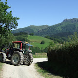 |
| HRP - Day 2 |
Day 2 started with a saunter down to Col d'Ibardin for a coffee and to grab some provisions. I then hiked along dirt tracks towards La Rhune. After Col de Lizuniaga I stopped to check my feet and realised that my toes were already blistered, just as predicted and despite taping them. I drained the blistered, re-taped them and carried on, still in a bit of a daze and not moving quickly. Suddenly I realised I was being caught rapidly by a fast moving hiker with trekking poles. I hung back to let him catch me more quickly and then joined him for a while, moving at a blistering pace in more ways than one. We passing through familiar territory since we were now on the GR11.
The hiker was a Frenchman called Claude who had started from Hendaye that morning, and was planning to complete the HRP in 18 days. I couldn't really see this was possible, but I admired his determination.
We stopped for a quick bite to eat at last year's GR11 first bivvy spot. I set off slightly ahead to catch another lone hiker who had just passed. I soon caught him and we started chatting. He was Robin from the Netherlands, and was also hiking the HRP. After the road crossing at Col d'Esquisaroy all 3 of us were climbing a steep dirt trail, but Claude was really hammering the pace so I closed him down at the crest of the ridge in order to confirm the route choice. He was planning to drop to Elizondo on the GR11 (which I did last year) whereas my book gave the route via Arizkun. I decided to stick with original plan, however Claude was talking about pressing on all the way to Aldudes that evening. I wasn't sure if that was possible, but I half wondered if I would see him there if I got down the hill quickly to Arizkun.
I looked back to see what Robin was up to, but we seemed to have dropped him, so I cut eastwards of the ridge and followed what I thought was the trail marked on my map. Unfortunately my map was not of good quality, and I had turned off the ridge too soon straight into a pretty impenetrable forest. I ended up thrashing around in the forest hurting my blistered feet and wasting time, and getting thoroughly confused. Eventually I decided to cut my losses by climbing back up towards the ridge and hacking across through the burnt gorse bushes to get to a good dirt road that looked like it might get me off the hill. My map only showed a small fraction of the tracks, so it was navigation by intuition and pot luck that got me down to Arizkun, but I'd wasted so much time, I'd more or less written off the idea of getting to Aldudes that evening.
I thought it would be more useful to have a proper rest, and to buy some more food and to eat and drink a good bit in Arizkun before setting off again. After one false start, I found the correct trail out of Arizkun, and then had to follow the guidebook descriptions to the letter to figure out the route through the maze of tracks up towards Burga. The descent off Burga was much rougher and more awkward than I was expecting, so when I finally hit Col Basabar around 9pm, it seemed sensible to pitch the tent, and to continue in the morning to Aldudes.
View HRP - Day 2 in a larger map
Friday, July 1, 2011
Day 1 - Hendaye to Col d'Ibardin (almost)
1st July 2011
Day 1 began with a 5am alarm call in Glasgow to catch a flight to London Stansted, then another flight to Biarritz, where I jumped on a bus to St Jean de Luz. I then had a 40 minute wait, which was just long enough to buy some food and sort my rucksack before catching the bus to Hendaye.
Hendaye was awash with surfers and beach goers. I spent a few minutes taping up my toes, and getting some photos on the beach before turning left and aiming for the Atlantic. It was around 6pm by the time I got going, so I knew I wouldn't get that far this evening. I was a bit spaced out from the travel and not organised enough to have the compass in my hand, so I repeatedly lost the GR10 markings and ended up just making up my own route to reach the hills above Biriatou.
After 3 hours or so I reached a flat area on a sort of col with grazing wild horses and pitched the tent, and was pleased to have a lie down.
View HRP - Day 1 in a larger map
 |
| HRP - Day 1 |
Day 1 began with a 5am alarm call in Glasgow to catch a flight to London Stansted, then another flight to Biarritz, where I jumped on a bus to St Jean de Luz. I then had a 40 minute wait, which was just long enough to buy some food and sort my rucksack before catching the bus to Hendaye.
Hendaye was awash with surfers and beach goers. I spent a few minutes taping up my toes, and getting some photos on the beach before turning left and aiming for the Atlantic. It was around 6pm by the time I got going, so I knew I wouldn't get that far this evening. I was a bit spaced out from the travel and not organised enough to have the compass in my hand, so I repeatedly lost the GR10 markings and ended up just making up my own route to reach the hills above Biriatou.
After 3 hours or so I reached a flat area on a sort of col with grazing wild horses and pitched the tent, and was pleased to have a lie down.
View HRP - Day 1 in a larger map
Subscribe to:
Posts (Atom)